Tel Be'ersheva National Park
Tel Be’er Sheva National Park (sometimes called Tel Sheva National Park) is a Judean fortress located about 2½ miles east of the modern city of Beersheba on a hill surrounded by two streams, Nahal Hebron and Nahal Be’er Sheva, and close to the new Bedouin town of Tel Sheva, known in Arabic as Tell es-Seba. Te fortress was strategically situated at the junction of main roads — eastward to the Judean Desert and Dead Sea, northward to Jerusalem, westward to Gaza, and southward to the center of the Negev. Many of the buildings on the tel have been partially reconstructed, and it is not difficult to imagine what this desert fortress would have looked like thousands of years ago.
This tel may have been the site of the biblical Be’ersheba (see discussion below). The expression “from Dan to Be’ersheba” indicates that Be’ersheba was at the southern limit of the Jewish kingdom in the monarchal period, (although King Solomon also conducted trade from Etzion Geber, close to Eilat). It was a border fortress and would have protected the kingdom against Amalekites and Midianites to the south. However, it was not the only fortress in the Negev and at the time of King Uzziah there were numerous small outposts in the Negev.
The two Israel travel books that everyone was waiting for!
Bestseller! "In and Around Jerusalem for Everyone - The Best Walks, Hikes and Outdoor Pools" and new! "The North of Israel for Everyone. The Best Family Activities, Hikes and Historic Sites" by Arnold Slyper — with essays, directions, maps, and much more.
For courier service from Pomeranz Booksellers in Jerusalem (tel: 02-623 5559) click here and here. For Amazon click here and here. For details about the books and their outstanding reviews click here and here.
There was a Chalcolithic settlement here from about 4,000 BCE to 3,000 BCE. There was then a gap in settlement of about 2,000 years and building was not renewed until the Israelite period, and settlement began again in the 11th century BCE during the time of either King Saul or King David.
The restoration work seen is mainly on structures from the 8th century BCE during the Kingdom of Judah, at which time it was a fortified city. The city was destroyed in 701 BCE during the campaign of the Assyrian king Sennacherib against the Judean king Hezekiah. The city remained in ruins until the Persian period when a small fortress was built. There were also fortresses here during the Herodian, Roman and early Arab periods.
Directions: Enter “Tel Be’er Sheba” into Waze.
Admission: This is a site of the Israel Nature and Parks Authority. During the summer, the park is open Sunday to Thursday and Saturday 8.00 a.m. to 5.00 p.m. and on Friday and holiday eves 8.00 a.m. to 4.00 p.m. The park closes 1 hour earlier in the winter. There are shaded picnic benches in the park near the entrance. There is no visitor center. There is an admission charge. Their phone number is 08-646 7286. This is their website
Public transport: Enter "Tel Be'er Sheba" into Moovit. There are buses from Be'ersheva. The closest bus stop is a 500-m/6-minute walk.

The well outside the Outer Gate.
Where was biblical Be’ersheba?
Could Tel Sheva be the biblical Be’ersheva? It makes sense. This site is in a strategic position controlling routes to the Arad, Hebron and the Coastal Plain.
On the other hand, no remains have been identified on this tel from the patriarchal period, which would have been in the Middle or Late Bronze Age. However, this is hardly surprising. Abraham was a nomad and his out-reach activities were outside the main cities. There is a deep well just outside the city gate dug during the Israelite period, perhaps for visiting nomads and other visitors, but it is highly unlikely that it was dug by Abraham or his family.
There are several wells in this area and identifying any particular one, or even a group of wells, as being dug by Abraham is well-nigh impossible. There is also no reason that he would have dug his wells on a hill.
Modern-day Be’ersheba is in a valley that is crossed by the Be’ersheba Stream. This is a windy river because of the hills surrounding the valley and this slows down the passage of the stream. This leaves time for water to seep into the underground aquifer. There are therefore many wells in this area, any of which could have been dug by Abraham and his descendants.
The story about Abraham’s well is told in the Book of Genesis. The servants of Abimelech, the king of Gerar, had taken over a well previously dug by Abraham, and Abraham needed to rectify the situation:
Then Abraham reproached Abimelech for the well of water which the servants of Abimelech had seized. But Abimelech said, “I do not know who did this; you did not tell me, nor have I heard of it until today.” Abraham took sheep and oxen and gave them to Abimelech, and the two of them made a pact. Abraham then set seven ewes of the flock by themselves, and Abimelech said to Abraham, “What mean these seven ewes which you have set apart?” He replied, “You are to accept these seven ewes from me as proof that I dug this well.” Hence that place was called Beer-sheba, for there the two of them swore an oath. When they had concluded the pact at Beer-sheba, Abimelech and Phicol, chief of his troops, departed and returned to the land of the Philistines (Genesis 21:25-32).
“Sheva” means either an oath or seven in Hebrew, both words having the same three root letters. Hence, Be’ersheba could mean the well of the oath or the well of the seven [ewes], or even both.
The next patriarch to reside in Be’ersheba was Abraham’s son Isaac. Isaac saw his mission as perpetuating the tradition of his father, to the extent that he repeated many of his father’s journeys, including to Be’ersheba. However, unlike the situation with his father, his relationship with the Philistines was not an amicable one, as they were jealous of his agricultural achievements:
He [Isaac] went from there to Be’ersheba, and God appeared to him that night . . . Abimelech went to him from Gerar with a group of his friends and Phicol general of his legion. . . . He made them a feast and they ate and drank. They awoke early in the morning and swore to one another. . . And it was on that very day that Isaac’s servants came and told him about the well they had dug and they said to him: “We have found water.” And he named it Shivah. Therefore, the name of the city is Be’ersheba until this very day (Genesiś 26:23-33).
It is noteworthy that Be’ersheba is now called “a city.” Another place called “Shiva” is also mentioned in this verse. This is of interest because two cities called Be’ersheba and Sheva are also mentioned in the Book of Joshua with respect to the inheritance of the tribe of Simeon. This tribe dwelt within the territory of Judah:
And the second draw of the lottery was for Simeon, to the tribe of the Children of Simeon according to their families. Their inheritance was situated amid the inheritance of Judah. And they received for their inheritance Be’er Sheva, Sheva and Moladah … thirteen cities and their villages . . . (Joshua 19:1-6).
Is it possible to fit all this into what we see today? Unfortunately, not. It seems likely that Abraham dug his wells in the area of the Be’ersheva Stream, since this is where the water table was easy to reach. Around one of his wells a city may have developed, or may already have been in existence. Around one such well a city and then a tel arose and this is where a Judean fortress was built.
We do not know of another archeological site of the city of Sheva, although by the time of Joshua such a place seems to have existed. This could have been anywhere in the Be’ersheva Valley (as could the city of Be’ersheva).
To complicate matters further, ancient ruins have been found in the old section of the modern city of Beersheba by the Bedouin market. However, extensive excavations have not been possible because of the surrounding structures. It is not impossible that this was the ancient site of Beersheba, or at least the site of a patriarchal well.
Tour of the Judean fortress
The path leading from the ticket office and restrooms is lined by a mudbrick wall, but this is not ancient.
Close to the entrance to the city is a four-horned altar. This is a model of a reconstruction, the original reconstructed altar being in the Israel Museum. It is from the 8th century BCE, or even earlier. The altar was not found intact, but its pieces were in secondary use in a wall of a building. This wall was destroyed during Sennacherib’s campaign. The horns were an important part of the altar, in that the blood of a sacrifice was sprinkled upon them.
It is of interest to compare this altar to the four-horned incense altar found at Tel Arad, which was also located in front of the Holy of Holies of a temple. A major difference between the altar at Tel Be’ersheba and the one at Arad is that this one is made of quarried ashlars and chiseled horns. It may well be, therefore, that the altar here was for pagan ritual. This would not be surprising as a number of the kings of Judah were pagan worshipper, including Hezekiah’s father Ahaz. If this were the case, Hezekiah would have destroyed this altar without providing it any respect and its ashlars were later used in other buildings.
The altar at Tel Arad, on the other hand, was built of small stones, faced with unchiseled stones, and the horns were unchiseled. The entire structure was buried together with its temple. There a biblical mandate to make altars to God only of whole stones and not to raise iron upon them (Deuteronomy 27:6). The presumption is that Hezekiah closed down the temple at Arad when he centralized worship in Jerusalem. Because it was an altar to God, he respectfully buried the altar when the temple was decommissioned.
Just outside the outer gate is a Well. It goes down to the water level, about 70 meters (230 feet), making it one of the deepest wells in Israel.
The Outer Gate was in addition to the inner gate and was dismantled in the 8th century BCE so that only the inner gate remained. Its base is made of rough stones and its upper section of sun-baked mud bricks.
The city was surrounded by a casement wall. Casement walls are a typical feature of fortified Israelite cities in the Iron Age, and are seen at Hazor, Gezer, Megiddo and Lachish. They are not an exclusively Jewish design and are found elsewhere in the Middle East, such as in Assyrian and Hittite cities. They consist of two parallel walls with a space between them divided into compartments or “casemates” — hence the name casement wall. The spaces between the walls were used for storage and they could also be filled with dirt and stones to strengthen the wall against battering rams. The homes within the fortress abutted the inner casement wall. The wall itself was made of mudbricks on a foundation of stone.

Four-horned altar made of quarried ashlars.

The walls were made of mudbricks on a foundation of stones.
The Inner Gate had a protective function. It had two chambers on each side and thick-walled towers. The towers have not been preserved. A 4-chambered gate with two chambers on each side was common in Israelite cities. Plastered benches were found in one of the chambers around its sides.
The gate led to a large open City Square, which is where judicial and commercial business was carried out and where the city elders would meet. All the streets led into this area, including two concentric streets around the city and streets perpendicular to these. The city had an oval shape.
The partially restored buildings provide a picture of a typical fortified Israelite city from the Judean period. There are ruins of partially reconstructed 4-roomed Israelite homes, which are very typical of the Israelite period. These homes typically had a rectilinear plan with four spaces or rooms, with a broad room at the back and three long spaces extending forward from the back wall. The large central space in the middle was separated from the other rooms by stone pillars and walls, and these may have supported a roof or second floor. The entrance to the house was from an exterior courtyard into the central space. The central courtyard was used for daily activities, such as food preparation and domestic chores, and may have been open to let in light, since there were no windows in the house. The side rooms functioned as storage areas and stables, while the back room was used for living and sleeping quarters.


Partially reconstructed ruins of a typical 4-roomed Israelite home.
The Storehouses. Hundreds of clay vessels were recovered in this structure.


The storehouses
A water system was needed for daily use and in case of a siege. The water system here is in the northeast corner of the city and is a large and impressive reservoir hewn into the soft chalk. It was constructed in the 9th century BCE. It has a 20-meter-deep stone-faced shaft, with a flight of stairs set into its wall, and a 700 m³ five-compartment reservoir hewn in the chalk rock. Most of the tunnel and stone steps that you see are original. The reservoir was fed from floodwaters from the Hebron Stream. An aqueduct led from the stream. This was at a slightly higher level than the reservoir, and can be seen when you exit from a tunnel. The water system fell out of use at the end of the Hellenistic period, apparently because of an earthquake that blocked the channel.
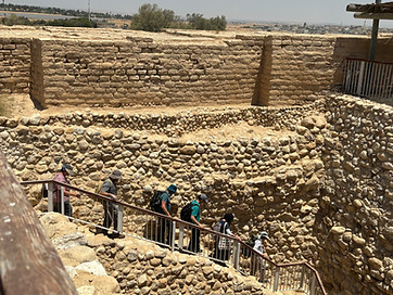
The 20-meter stone-faced shaft to the reservoir.

The aqueduct that brought winter floodwater from the Hebron Stream to the reservoir inside the city.
The Tower. There is an observation tower with a spiral staircase in the center of the mound. It is in the former Roman part of the city. It leads to a balcony from which can be viewed the entire ruins and also the area around the park.
Attractions in Be'ersheva on this website:
The Midbarium Desert Animal Park
Abraham's Well International Visitors Center
The Memorial to the Negev Brigade