Taninim Stream Nature Reserve
Tananim Stream Nature Reserve is a park located 6 km to the north of Caesarea and just off Route 2, which contains a reconstructed ancient dam, a wetland refuge for endangered plants, and hiking paths.
My widely acclaimed, best-selling guide for exploring in and around Jerusalem: "In and Around Jerusalem for Everyone - The Best Walks, Hikes and Outdoor Pools" by Arnold Slyper
For FREE, speedy, home, courier service from Pomeranz Booksellers in Jerusalem click here (tel: 02-623 5559) and for Amazon click here. To see details about the book and its outstanding reviews click here.
In the Byzantine period, in the late 4th century or early 5th century CE, a new aqueduct system, a Lower Aqueduct, was built to provide the expanding city of Caesarea with additional water from Tananim Stream and springs close to the coast. But how could water be brought to Caesarea from a stream that was at the same level as the city? The solution was to dam up the stream and create a huge lake three meters above the level of the stream. However, a functional system like this needs careful maintenance, which was not provided when Caesarea diminished in importance, and this resulted eventually in a marshland. Already by the late medieval period, travelers described the region as malarial.
The swamp was drained in the 1920s. Some of this area is now a park and contains a very pleasant, easy trail. There is no English brochure but the trail is labelled via signs in Hebrew and English. The stream was named Taninim – Hebrew for crocodiles – because these reptiles once inhabited the swamps until the beginning of the 20th century. The sluice for the dam and the water mills you see are recreated.
Because the springs produce water with an increased salinity, water from the Lower Aqueduct was not used for drinking but for other purposes. It was covered over all the way to Caesarea and one of its arches can be seen from the park. It fell into disuse during the Muslim period. Children can now play in its shallow water, although it can be slippery. Six flour mills were built in the stream in the Byzantine period and seven mills in the Ottoman period.
The wetlands were drained by Baron Edmond de Rothschild between 1922 to 1932, with the intention of developing this land for settlement. Edmond de Rothschild also established a clay pipe factory here, although this was not successful. The workers he employed for this work were housed nearby and this became the Arab village of Jist az-Zarqa. The reserve protects the core wetland zone around the stream, including springs, channels, and seasonal marsh patches, while the remainder of the land is used for agriculture.
There is a longer 5 km Stream Trail which separates from the Dam Trail and goes along the stream and adjacent to the village, although it is currently closed.
A walk on the Dam Trail:
Time: About ¾ hour.
Distance: About 1¾ Km.
Type of walk: Circular
Difficulty: This is an easy walk, but is not suitable for a stroller or wheelchair.
Directions: The park is open in the summer Sunday to Thursday and Saturday from 8.00 a.m. to 5.00 p.m. and Friday and holiday eves 8.00 a.m. to 4.00 p.m. In the winter the park closes an hour earlier. Admission is up to 1 hour before closing. There is an admission charge. There are shaded picnic tables by the park entrance. Also cold water. Their phone number is 04 626 5151.
Public transport: Enter “Taninim Stream Nature Reserve.” The nearest bus stop is a 1.4-Km/17-minute walk from the reserve.

There were crocodiles in this stream and wetlands until recently. They were a left-over for when this was a tropical area.

A wooden warkway within the reserve
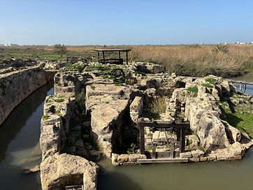
Reconstructed mills from the Byzantine and Ottoman periiods

The dam was built during the Roman-Byzantine period to raise the water level so as to supply Caesarea with water via gravity.
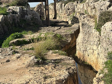
The Lower Aqueduct to Caesarea. The remnants of an arch can be seen from the reserve.

A reconstructed sluice from the late Roman/Byzantine period on the dam
Nearby places of interest:
The High Aqueduct system for Caesarea at Caesarea’s Aqueduct Beach
There is a well in Caesarea, although this was insufficient for the water needs of the city. Water was therefore brought from distant springs by a High Aqueduct system built on long rows of stone arches, and this supplied Caesarea with plentiful water for centuries. Remains of a short section can be seen at Caesarea’s Aqueduct Beach.
This aqueduct system underwent three phases, all of which can be seen here. The first system was built by Herod of neatly cut kurkar sandstone blocks in the late 1st century BCE, and this brought water from springs near Shuni at the foot of Mount Carmel. This is the arch system closest to the parking lot. An adjoining second parallel channel was added during the reign of Hadrian, and this doubled the water supply for the growing city and army units stationed there. It was constructed by the Roman Legion, which was used for this type of public works.
A recent excavation report describes a third major phase in the aqueduct’s history, interpreted as a later channel replacing earlier ones, dating to the mid-Byzantine period (6th century CE). It was not built as an entirely new aqueduct, but as a substantial reconstruction on the corridor of or in place of older sections.
Directions: Enter “חניון חוף אקוודוקט” into Waze.
