Top three attractions in Natanya
Worthwhile activities in Natanya include a hike in Poleg Nature Reserve, a visit to Planetanya, and walk in Sergeants' Park
Hike in Poleg Nature Reserve
This is a short but extremely beautiful hike along a hilly ridge of calcareous sandstone and loose sand adjacent to a broad sandy beach, and then above the bank of the Poleg Stream. There is a large variety of landscapes and habitats with a rich array of flora and fauna.
Time: About 1 hour.
Distance: 2.3 Km
Type of hike: Circular
Directions and parking: Enter “שמורת נחל פולג” into Waze. This will lead you through the grounds of the Wingate Institute and for this you will need to take a parking ticket. Waze will bring you to a parking lot which is part of the Wingate Institute. The parking fee for the hour’s hike will cost about 25 NIS. (Be aware that there is another nearby park called Sha’ar Poleg Nature Reserve on the other side of Route 2. If you just put Poleg Nature Reserve into Waze, it does not go through the Wingate Institute and it will lead you to this other nature reserve.
Difficulty: This hike is not difficult, but walking on loose sand for much of the way needs more effort than walking on firmer ground.

The must-have guide for exploring in and around Jerusalem
"In and Around Jerusalem for Everyone - The Best Walks, Hikes and Outdoor Pools"
For FREE, speedy, home, courier service from Pomeranz Booksellers in Jerusalem click here (tel: 02-623 5559) and for Amazon click here. To view outstanding reviews click here.


The hike:
-
From the parking lot, head up the steps and you will come shortly to the intersection of the green and blue trails. This will, in fact, be the last markings you will see as there are no markings on the trails. However, the direction of the trails is fairly intuitive and you can always check your progress on the map link. Turn to the left on the black trail.
-
This will bring you to a hill of sand without any clear path, but head to the paths on the top of the hill.
-
You will come to a T-junction by a wire fence. Turn to the right on what is now a red trail, although there are no markings on the trail. This will bring you to picturesque promontories overlooking the sea. This trail will gradually bring you down to the beach.
-
Turn to the right on a broad sandy path just above the level of the beach and away from the sea. This is a blue trail on the map. After some distance you will see that you are walking on top of the bank of the Poleg Stream.
-
The path narrows and comes eventually to its intersection with the green trail. The steps and the parking lot are ahead of you.

Map of Nahal Poleg Nature Reserve
A visit to Planetanya
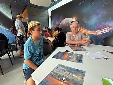
Planetanya is a unique center in Natanya with a planetarium that covers the broad fields of science, space and astronomy. As distinct from science museums, it offers a variety of guided activities designed to keep children and adults engaged. All the activities are in Hebrew. The center opened in June 2016 thanks to support from a Japanese benefactor and the municipality.
Directions and parking: Enter “Planetanya” into Waze and click on “Planetanya-Planetarium Netanya.” There is a large free parking lot in front of the museum.
Admission: The activity commences promptly at the time marked on your ticket. The gates to the building open about 10 minutes before this time, at which time your ticket is checked on your phone. There is no cafeteria or picnic tables. There is a very small gift shop. Cold water is available. Their phone number is 09 959-7330. This is their website:
Public transport: Enter “Planetanya” into Moovit and click on “Planetanya-Planetarium Netanya.”

Demonstration of the effect of static electricity
Activities available at the museum include guided tours, workshops, summer camps, telescope viewing, evening activities, films, lectures, and performances. A typical tour lasts 2 hours with about 6 activities led by a museum guide. All are designed to keep everyone engaged and could include for example an interactive demonstration of static electricity, a hands-on activity making a paper sundial, spending time in an outdoor science garden, and watching high-resolution star fields and space visuals in the planetarium. Hours are varied depending on the activities programmed. There is a Japanese garden that can be visited.
In the outdoor science garden
Hands-on activity making a paper sundial that actually works. Just turn it to the north.
A walk around Sergeants’ Grove
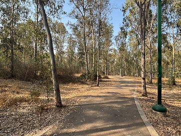
This is a well-kept, pastoral park in the Kiryat Hasharon neighborhood in the southeastern edge of Netanya that contains a grove of predominantly eucalyptus trees. It is open 24/7 and is wonderful for a short bike ride or a walk round the periphery on asphalt-covered paths. There are benches along the way.
Time: About 40 minutes to walk around the periphery
Distance: About 1¾ km around the periphery
Type of walk: Circular
Directions and parking: Enter “Sergeants’ Grove” into Waze and click on “Sergeants’ Grove, Alonim Street, Netanya.” There is street parking by the sides of the park.
Public transport: Enter “Sergeants’ Grove” into Moovit and click on “Sergeants’ Grove, Alonim Street, Netanya.”
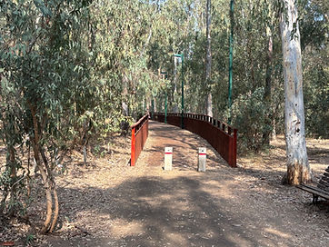
Bridge over the seasonal pool
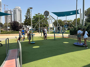
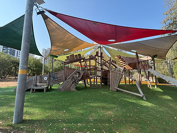
There are multiple entry points into the park, especially at the corners. The walking and biking lanes are clearly marked. The park contains a seasonal pool that fills after early rains but typically dries by late May and which attracts amphibians and ducks. It is viewed from a wooden bridge, which is part of the peripheral path. The eucalyptus trees were planted by the British in the mandate period and there is also some wild oak. There is very little brush, and this gives the park an ordered appearance. There are two shaded children’s playgrounds with modern climbing equipment. There used to be a tower, but it no longer exists. There is an area with picnic benches and also a drinking water.fountain.
The grove is home to around 300 plant species native to the Sharon region, including purple iris, hyacinth squill, anemone, and tulip, including 30 rare varieties. Throughout the path are signs in Hebrew explaining about the flora and fauna.
The grove’s name commemorates two British sergeants who were executed by the Irgun in July 1947 as a retaliatory act following the execution of Irgun members. This took place in a eucalyptus grove near Netanya.
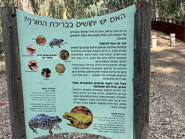
There is information on both sides of the notices.
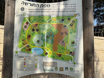
Map of the park
Links to the best family activities, hikes and historic sites in the GOLAN, EASTERN GALILEE, UPPER GALILEE, LOWER GALILEE, JORDAN VALLEY & LAKE KINNERET, the SHEFELAH, TEL AVIV-YAFFO and surroundings, NORTH of TEL AVIV, and SOUTH of TEL AVIV.