Two family hikes at Ramat HaNadiv
Walking through its beautiful gardens is not the only worthwhile activity in Ramat Hanadiv. The grounds of Ramat Hanadiv are very extensive and two trails, the Spring Trail and Manor Trail, have been laid out for hiking. This area was settled in the past by ancient civilizations, and both hikes contain interesting historical and botanical features, as well as offering impressive views.
The must-have guide for exploring in and around Jerusalem
"In and Around Jerusalem for Everyone - The Best Walks, Hikes and Outdoor Pools"
For FREE, speedy, home, courier service from Pomeranz Booksellers in Jerusalem click here (tel: 02-623 5559) and for Amazon click here. To view outstanding reviews click here.
Both the hikes described here are also described in greater detail on line: The Spring Trail and The Manor Trail.
You can also purchase a booklet about the two trails in their store for 5 NIS each. The description below describes the highlights of these two trails, but not the detail provided by these other resources and the on-site signs.
The trailhead for both hikes is the same and is directly opposite the park store, on the far side of the parking lot. For the Spring Trail follow the blue-markings and for the Manor Trail follow the red markings.
Be aware, though, that there is a separate exit for these two trails, which is a bit further along. So, make sure you have the right entrance directly opposite the Visitor Center.
The Spring Trail (blue-marked trail)
This hike to the spring, aqueduct and pool of Ein Zur is on the southern edge of the Carmel Mountain and provides beautiful views over the Hanadiv Valley, which extends all the way to the coast. On the other side of the valley are the hills of Samaria.
Time: Approximately 2½ Km
Distance: About 1½ hours
Type of hike: Circular
Difficulty: The trail is minimally difficult in that there is bare rock on sections of the path, but only a short section involves a descent on rock. Walking shoes or sneakers with an adequate tread are advised and not flip-flops.
The trailhead: The starting point of the trail is a gate opposite the Visitor Center on the far side of the parking lot and directly opposite the main path into the gardens. Go through the gate to the intersection of the blue-marked and red-marked trails and turn slightly leftwards along the blue-marked trail.

The pool by the spring of Ein Tzur.
Throughout the trail are identification numbers for the different sites:
-
#1 is an Observation Point. Below you is Hanadiv Valley and immediately south of it is the town of Binyamina. To the north are the houses of Zichron Ya’akov.
-
The trail continues to a stone step where there is a large carob tree (#2). #3 is a Tabor oak and #4 artificial wetlands.
-
You will soon reach the ruins of settlement by the spring Ein Tzur, which includes a Roman bathhouse (#5) built at the end of the 1st century BCE and that continued in use until the Great Revolt against Rome in 70 CE. From the metal stairway and platform above the bathhouse you can make out the typical four rooms of this type of structure, which includes an undressing room, cold water room, warm room (tepidarium), and hot bath or sauna room (caldarium). The latter was heated by warm air circulating beneath the floor.
#6 is the spring of Ein Tzur, its tunnel, aqueduct and pooll. The tunnel consists of three shafts that wind 47 meters along a natural fissure in the bedrock to the spring. The large pool at the end of the aqueduct suppled water to the bathhouse and would also have been used for agriculture and as a bathing pool. It is suitable for children to get wet.
-
The trail goes up stone stairs through a gap in the wall by the aqueduct and then turns to the left. You cannot not miss the ruins of a dovecote or columbarium (#7) with its round tower base. Birds entered the tower through small openings in the upper section. Workers entered the tower by means of a ladder and an opening on the side of the building.
-
The trail goes up stone stairs through a gap in the wall and then turns left to a large archeological complex Horvat ‘Aleq (#8). This site was inhabited from prehistoric to the 2nd century CE, including Persian, Hellenistic and Roman periods. The site has been reconstructed as it was when it reached its peak in the early Hellenistic period. There was also settlement at the end of the Ottoman era as the village of Umm el-‘Aleq.
-
The last set of ruins you will pass are those of Beit Khouri #9. These are the remnant of a large farmhouse built by the El-Khouri family, a Christian Arab family, in about 1880. The land was later purchased in 1913 by the Jewish Colonization Society on behalf of Baron Edmond de Rothschild. Three groups of pioneers attempted to settle here between 1919 to 1923. However, the conditions were too difficult and they abandoned their attempts, and the land is now part of the grounds of Ramat Hanadiv. Beyond the second arch there happens to be a picnic bench, which can only be seen by walking beyond the arch.
-
#10 is a shallow ancient quarry. The limestone that was quarried was no more than 6 meter deep before reaching soft bedrock.

On the trail with wonderful views over the Hanadiv Valley.

The ruins of Beit Khouri, a large farmhouse built around 1880, the land of which was purchased by Baron Edmond de Rothschild.

Overlooking the Roman bathhouse. The short pillars supported a floor with air heating.
The Manor Trail (red-marked trail)
This trail takes you to the ruins of a Second Temple and Byzantine farmstead that has much of interest around it, including a wonderful view over the coastal plain. It then proceeds to a descent to Wadi Timsach, which is slightly difficult hiking. You may wish to skip this second part of the trail and return from the manor the same way you came. Alternatively, you can return along the purple-heart-marked trail.
Time: About 2 hours 15 minutes for the circular hike
Distance: Almost 4 Km for the entire circular hike
Type of hike: Circular
Difficulty: The first part of the trail to the manor is easy hiking. However, the sections after this are mild to moderately difficult with some climbing down on rocks. Hiking poles can be useful.
Traihead: The entrance path to this circular hike is straight ahead, while the return path joins it to its right by the parking lot. You will not confuse them since the entrance path is clearly indicated by red markings. It is also part of the Schvil Yisrael, which is not the case for the return path.

The view from Wadi Timsach.
Throughout the trail are identification numbers for the different sites:
-
The stone quarries (#1) are quite shallow, since the miners chiseled no further than the soft bedrock. #2 is a Cypress Grove. The highlight of this hike is Horvat Aqav (#3) on the highest point on this part of the ridge of the Carmel range.
This ruin is from two periods. During the Second Temple period there was a fortified farmstead here. It is estimated that it had about 20 people occupants, including its owner, servants and workers. It was abandoned during the Great Revolt against Rome. On top of its ruins a country manor house was built in the Byzantine period (4th to 7th centuries CE), and this functioned as a residence, workplace and storehouse. It remained occupied until the Muslim conquest in the 7th century. The nature of these two habitations is described in greater detail in the brochure, online and on the signs.
The mikveh in front of the building is from the Second Temple period. Agricultural equipment from the Byzantine period is displayed by the side of the ruins and is described by signs. The olive and fig trees and grape vines were recently planted and were the type of trees that would have been here when these buildings were habited.
Do look over the coastal plain from the Observation Plaza. A sign indicates what you are viewing. The hills of Samaria, Ramot Menashe and the Carmel range are to the east.
Looking at the beauty of the agricultural land beneath you, it is difficult to imagine that this was once malaria-infested swamp. It was Baron de Rothschild who began draining it.
From the front of the building, the well-marked trail goes to the right (facing the building) along the Ramat Hanadiv cliffs. One might anticipate lots of views of the coastal plain, but this is not the case because of the scrubland foliage. The trail descends to Wadi Timsach and turns right along the wadi.


View of the coastal plain from the Observation Plaza.
Ruins of the Manor from the Byzantine period.

Threshing floor from the Second Temple Period
The purple heart trail
There is also a third trail in the park, but which is not shown on their map. It is marked with purple hearts on the wooden poles, and there are notices with the purple heart sign that suggest introspection about the nature you are passing and how this influences your emotions. These signs are on the red-marked trail. However, at the manor, this trail turns right rather than straight ahead to the wadi. Arrows on the signs indicate the direction to go. However, there is a point at which the sign is misleading. This is a point with a display of stones (see picture). The arrow seems to indicate to go ahead onto the red trail – but this will lead you to the wadi. In actuality, you should go in the opposite direction along the red-marked trail and this will lead you along the final section of the red-marked trail.

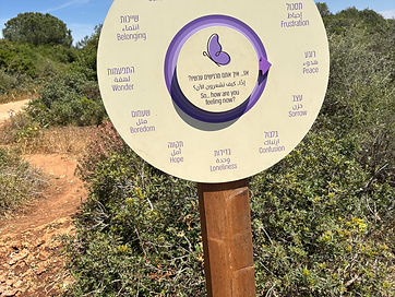

By this exhibit, make sure you go in the right direction along the red-marked trail.

Map of the Manor Trail and Spring Trail
To follow your location on your smart phone, click on https://israelhiking.osm.org.il/share/JkKsCe0zRD
Click on the black box with a cross at the top left of the map and it should change color to green. It is not necessary to download the free app unless you wish to.
Nearby places of interest
HaNadiv Farm. This is by the entrance to Ramat Hanadiv, although it is not part of Ramat Hanadiv estate. The farm is advertised as an experiential farm for the whole family, where you can spend time with your children in nature, taste natural fruits and vegetables, help the farm staff take care of the greenhouses, pet and feed farm animals, create surprising creations in the creative area, and enjoy the peace and quiet. Bikes can be rented for use in Ramat Hanadiv. There is a small tractor to ride around. Vegetables can be tasted. The farm is open Sunday to Thursday 9 a.m. to 4 p.m. and Friday and Saturday 9 a.m. to 2 p.m. There is an admission charge. Their phone number is 054 675-0950. This is their website: